 Barnorama Welcome To The Fun Barn
Last updated: November 16, 2026
Key takeaways
- NOAA says El Niño is still strengthening, and it gives a better than 79% chance that a strong-to-very strong event lasts through January to March 2027.
- Forecasters put the odds of a historic El Niño, stronger than any on record since 1950, at about 60% for late 2026.
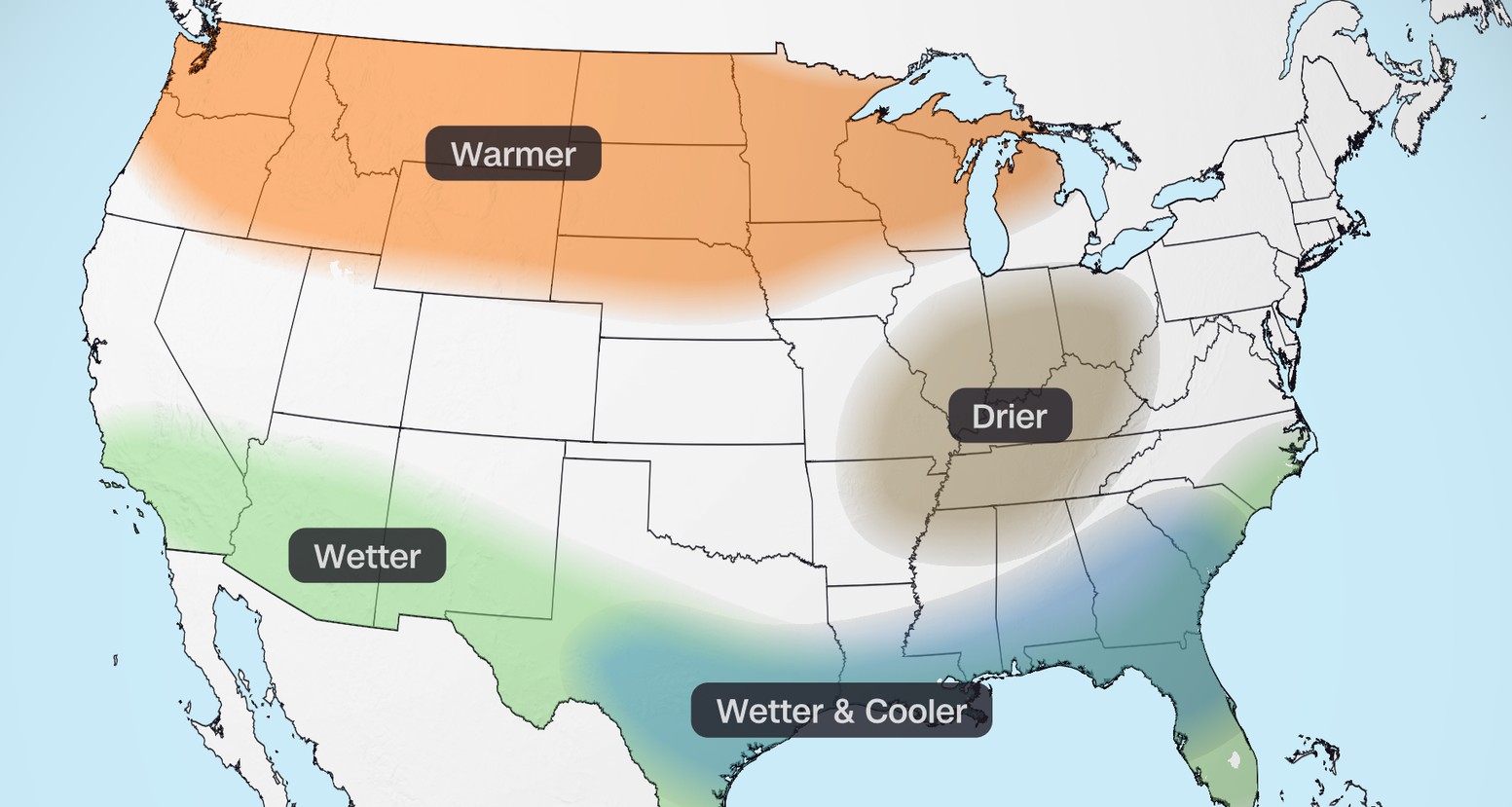
- NOAA’s winter outlook favors a warmer-than-average northern US and a wetter southern US, from California to Florida and up the East Coast.
- Wetter doesn’t automatically mean snowier, especially across the northern states.
- NOAA updates its seasonal outlook on November 19 and its next El Niño discussion is due December 10.
El Niño weather is back in the headlines, and for good reason. The warm-water event in the Pacific Ocean has been building since June and is now on track to rank among the strongest ever measured. Here’s a plain-English look at what’s happening, what the official forecasts say about this winter, and what it could mean where you live.
What is El Niño?
El Niño is the warm phase of a natural climate cycle called the El Niño–Southern Oscillation, or ENSO. Every few years, surface waters in the central and eastern tropical Pacific become unusually warm. That extra heat changes where storms form and shifts the jet stream, the high-altitude river of air that steers weather across North America.
The effects are usually strongest in the US during winter. El Niño doesn’t guarantee any particular weather on a given day, but it tilts the odds for the season as a whole.
How strong is this El Niño?
NOAA’s Climate Prediction Center (CPC) issued an El Niño Advisory on June 11, 2026, once ocean and atmosphere conditions shifted into an El Niño pattern. Since then, the event has kept growing.
In its latest monthly update, released November 12, the CPC said El Niño “continues to strengthen.” The key numbers from that update:
NOAA’s November 12 update at a glance
- Niño-3.4 region: +2.5°C above average (the main region forecasters watch)
- Niño-3 region: +3.6°C
- Niño-1+2 region (near South America): +4.4°C
- Strong-to-very strong El Niño through January to March 2027: greater than 79% chance
- Historic event, stronger than any since 1950: about 60% chance for October to December and November to January
NOAA defines a “historic” event as one where a three-month average of its relative index reaches +2.5°C or more. That relative index compares the key Pacific region with the tropics as a whole, which helps separate El Niño from general ocean warming.
The CPC expects El Niño to keep strengthening before it begins to weaken in early 2027.
Is it a “super El Niño”?
You’ll see the phrase “super El Niño” everywhere this fall. It’s informal shorthand, not an official NOAA category. NOAA’s own terms are “strong,” “very strong” and, this year, “historic.” If the forecasts hold, though, this event would qualify as “super” by almost anyone’s definition.
What NOAA’s winter outlook says
NOAA released its US Winter Outlook for December 2026 through February 2027 on October 15. It closely follows the classic El Niño pattern:
Temperature
- Warmer than average is favored across much of the northern US, with the best odds in the Pacific Northwest, the northern Rockies, the Midwest, the Mississippi Valley, much of the East and Alaska.
- Near normal is most likely in parts of the Southeast, including Florida.
- Equal chances of a warm, cool or average winter apply to much of the Southwest and Hawaii.
The Associated Press noted that no part of the Lower 48 is forecast to be colder than normal this winter.
Rain and snow
- Wetter than average is favored across the southern tier, from California to Florida, and northward along the East Coast.
- Drier than average is favored in parts of the northern Rockies and the Great Lakes region.
- Drought relief is expected across the Southwest, the southern Plains, the Southeast and parts of the East Coast. Drought could develop or worsen in parts of the northern Rockies and the inland Northwest.
What it could mean where you live
South and Southwest: A stormier, wetter winter is the most likely outcome. That’s good news for drought-stricken areas, but heavy rain can also bring flooding. California in particular should watch for strong storm systems.
Southeast and Florida: Wetter than normal, with temperatures closer to average than in the north.
Northern tier and Great Lakes: Milder than usual, and possibly drier. Snow lovers in the North may be disappointed, since warmer air means more precipitation could fall as rain.
Northeast and East Coast: Warmer than average, with odds tilted toward more precipitation. Whether that falls as rain or snow will depend on individual storms.
Why the forecast still comes with caveats
Even a record El Niño only shifts the odds. NOAA itself says El Niño-related impacts are more likely this winter but “not guaranteed.” Other factors, including short-term blasts of Arctic air, can still deliver cold snaps and snowstorms in places the seasonal map shows as mild.
There’s also a simpler reason for caution: forecasters have very few events this strong to learn from. Only a handful of El Niños since 1950 have come close to this one, so there’s less history to guide predictions.
Practical steps for an El Niño winter
- In the South and West, clear gutters and drains, check your sump pump if you have one, and look up your local flood risk. Remember that standard homeowners insurance usually doesn’t cover flooding.
- In wildfire burn areas, pay extra attention to flash flood and mudslide warnings during heavy rain.
- Everywhere, keep a basic emergency kit ready (flashlight, batteries, water and a phone charger), and sign up for local weather alerts.
- Travelers and skiers should check short-range forecasts closer to their trip dates instead of relying on the seasonal outlook.
What to watch next
Two dates are worth marking. NOAA updates its seasonal outlook on November 19, and the CPC’s next monthly El Niño discussion is scheduled for December 10. Both will show whether the event is peaking as expected and whether the winter forecast is shifting.
Sources
- ENSO Diagnostic Discussion, November 12, 2026 (NOAA Climate Prediction Center)
- ENSO Diagnostic Discussion, October 8, 2026 (NOAA Climate Prediction Center)
- ENSO Conditions and Alerts (NOAA Coral Reef Watch)
- US winter is likely to be wetter and warmer, forecasters say (Associated Press via KPTV, October 16, 2026)
- Very strong El Niño favors wetter South and warmer North in NOAA’s 2026–27 winter outlook (The Watchers, October 16, 2026)
- El Niño develops, NOAA estimates 63% chance of a very strong event (The Watchers, June 11, 2026)
- Super El Niño fueled winter could unleash more storms (FOX Weather)
- What El Niño Is Doing to Shape NOAA’s Latest Winter Outlook (Greenhouse Grower)
- El Niño Is Strengthening, and the Odds of a “Historic” Event Have Increased (Powder, November 2026)
- How super El Niño forecasts have changed (Newsweek)